|
| at: |
Kisatchie National Forest - Kisatchie District |
Data from USFS GIS
 show on map
 animate
Trail users:


Elevation Profile
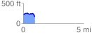
 0.963561 mi
 88.43 ft
 121.56 ft
 -33.13 ft
 2.39 %
GPX Downloads: Track Route
![]()
|
| at: |
Kisatchie National Forest - Kisatchie District |
show on map
animate
0.963561 mi
88.43 ft
121.56 ft
-33.13 ft
2.39 %