|
| at: |
Kisatchie National Forest - Kisatchie District |
Data from USFS GIS
 show on map
 animate
Trail users:


Elevation Profile
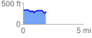
 1.892174 mi
 138.56 ft
 169.76 ft
 -31.20 ft
 1.70 %
GPX Downloads: Track Route
![]()
|
| at: |
Kisatchie National Forest - Kisatchie District |
show on map
animate
1.892174 mi
138.56 ft
169.76 ft
-31.20 ft
1.70 %