| at: |
Kisatchie National Forest - Kisatchie District |
Data from USFS GIS
 show on map
 animate
Trail users:


Elevation Profile
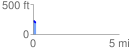
 0.158243 mi
 0.31 ft
 34.39 ft
 -34.08 ft
 4.12 %
GPX Downloads: Track Route
![]()
| at: |
Kisatchie National Forest - Kisatchie District |
show on map
animate
0.158243 mi
0.31 ft
34.39 ft
-34.08 ft
4.12 %