| at: |
Kisatchie National Forest - Kisatchie District |
Data from USFS GIS
 show on map
 animate
Trail users:


Elevation Profile
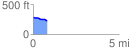
 0.803782 mi
 4.50 ft
 61.38 ft
 -56.88 ft
 1.45 %
GPX Downloads: Track Route
![]()
| at: |
Kisatchie National Forest - Kisatchie District |
show on map
animate
0.803782 mi
4.50 ft
61.38 ft
-56.88 ft
1.45 %