| at: |
Kisatchie National Forest - Kisatchie District |
Data from USFS GIS
 show on map
 animate
Trail users:


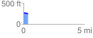
Elevation Profile
 0.383030 mi
 7.10 ft
 25.61 ft
 -18.51 ft
 1.27 %
GPX Downloads: Track Route
![]()
| at: |
Kisatchie National Forest - Kisatchie District |
show on map
animate
0.383030 mi
7.10 ft
25.61 ft
-18.51 ft
1.27 %