|
| at: |
Kisatchie National Forest - Kisatchie District |
Data from USFS GIS
 show on map
 animate
Trail users:


Elevation Profile
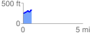
 0.745851 mi
 109.45 ft
 34.98 ft
 74.47 ft
 2.78 %
GPX Downloads: Track Route
![]()
|
| at: |
Kisatchie National Forest - Kisatchie District |
show on map
animate
0.745851 mi
109.45 ft
34.98 ft
74.47 ft
2.78 %