| at: |
Kisatchie National Forest - Kisatchie District |
Data from USFS GIS
 show on map
 animate
Trail users:

Elevation Profile
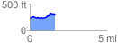
 1.612340 mi
 144.69 ft
 68.44 ft
 76.24 ft
 1.70 %
GPX Downloads: Track Route
![]()
| at: |
Kisatchie National Forest - Kisatchie District |
show on map
animate
1.612340 mi
144.69 ft
68.44 ft
76.24 ft
1.70 %