| at: |
Kisatchie National Forest - Kisatchie District |
Data from USFS GIS
 show on map
 animate
Trail users:


Elevation Profile
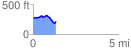
 1.348349 mi
 105.91 ft
 158.44 ft
 -52.53 ft
 2.23 %
GPX Downloads: Track Route
![]()
| at: |
Kisatchie National Forest - Kisatchie District |
show on map
animate
1.348349 mi
105.91 ft
158.44 ft
-52.53 ft
2.23 %