|
| at: |
Kisatchie National Forest - Calcasieu District - Vernon Unit |
Data from USFS GIS
 show on map
 animate
Trail users:


Elevation Profile
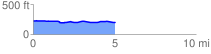
 5.053481 mi
 85.89 ft
 101.25 ft
 -15.36 ft
 0.38 %
GPX Downloads: Track Route
![]()
|
| at: |
Kisatchie National Forest - Calcasieu District - Vernon Unit |
show on map
animate
5.053481 mi
85.89 ft
101.25 ft
-15.36 ft
0.38 %