| at: |
Kisatchie National Forest - Calcasieu District - Vernon Unit |
Data from USFS GIS
 show on map
 animate
Trail users:


Elevation Profile
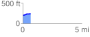
 0.681490 mi
 45.36 ft
 3.46 ft
 41.90 ft
 1.26 %
GPX Downloads: Track Route
![]()
| at: |
Kisatchie National Forest - Calcasieu District - Vernon Unit |
show on map
animate
0.681490 mi
45.36 ft
3.46 ft
41.90 ft
1.26 %