| at: |
Fort Mountain State Park Area |
Data from David Muse
 show on map
 animate
Trail users:


Elevation Profile
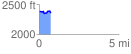
 0.719093 mi
 44.07 ft
 76.83 ft
 -32.76 ft
 2.02 %
GPX Downloads: Track Route
![]()
| at: |
Fort Mountain State Park Area |
show on map
animate
0.719093 mi
44.07 ft
76.83 ft
-32.76 ft
2.02 %