| at: |
Kisatchie National Forest - Calcasieu District - Vernon Unit |
Data from USFS GIS
 show on map
 animate
Trail users:


Elevation Profile
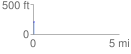
 0.085912 mi
 4.08 ft
 8.60 ft
 -4.52 ft
 1.90 %
GPX Downloads: Track Route
![]()
| at: |
Kisatchie National Forest - Calcasieu District - Vernon Unit |
show on map
animate
0.085912 mi
4.08 ft
8.60 ft
-4.52 ft
1.90 %