| at: |
Kisatchie National Forest - Calcasieu District - Vernon Unit |
Data from USFS GIS
 show on map
 animate
Trail users:


Elevation Profile
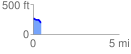
 0.450875 mi
 4.02 ft
 73.03 ft
 -69.02 ft
 3.07 %
GPX Downloads: Track Route
![]()
| at: |
Kisatchie National Forest - Calcasieu District - Vernon Unit |
show on map
animate
0.450875 mi
4.02 ft
73.03 ft
-69.02 ft
3.07 %