|
| at: |
Sumter National Forest - Enoree District |
Data from USFS GIS
 show on map
 animate
Trail users:


Elevation Profile
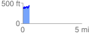
 0.558866 mi
 152.53 ft
 105.70 ft
 46.83 ft
 5.17 %
GPX Downloads: Track Route
![]()
|
| at: |
Sumter National Forest - Enoree District |
show on map
animate
0.558866 mi
152.53 ft
105.70 ft
46.83 ft
5.17 %