| at: |
Sumter National Forest - Enoree District |
Data from USFS GIS
 show on map
 animate
Trail users:


Elevation Profile
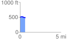
 0.642578 mi
 42.75 ft
 60.96 ft
 -18.21 ft
 1.80 %
GPX Downloads: Track Route
![]()
| at: |
Sumter National Forest - Enoree District |
show on map
animate
0.642578 mi
42.75 ft
60.96 ft
-18.21 ft
1.80 %