|
| at: |
Sumter National Forest - Enoree District |
Data from USFS GIS
 show on map
 animate
Trail users:


Elevation Profile
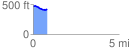
 0.804263 mi
 32.61 ft
 89.71 ft
 -57.10 ft
 2.11 %
GPX Downloads: Track Route
![]()
|
| at: |
Sumter National Forest - Enoree District |
show on map
animate
0.804263 mi
32.61 ft
89.71 ft
-57.10 ft
2.11 %