|
| at: |
Sumter National Forest - Enoree District |
Data from USFS GIS
 show on map
 animate
Trail users:


Elevation Profile
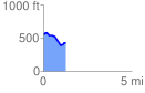
 1.250100 mi
 83.94 ft
 208.87 ft
 -124.92 ft
 3.16 %
GPX Downloads: Track Route
![]()
|
| at: |
Sumter National Forest - Enoree District |
show on map
animate
1.250100 mi
83.94 ft
208.87 ft
-124.92 ft
3.16 %