| at: |
Sumter National Forest - Enoree District |
Data from USFS GIS
 show on map
 animate
Trail users:


Elevation Profile
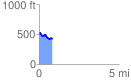
 0.827794 mi
 69.22 ft
 148.84 ft
 -79.62 ft
 3.41 %
GPX Downloads: Track Route
![]()
| at: |
Sumter National Forest - Enoree District |
show on map
animate
0.827794 mi
69.22 ft
148.84 ft
-79.62 ft
3.41 %