| at: |
Sumter National Forest - Enoree District |
Data from USFS GIS
 show on map
 animate
Trail users:


Elevation Profile
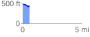
 0.599756 mi
 26.18 ft
 65.97 ft
 -39.79 ft
 2.08 %
GPX Downloads: Track Route
![]()
| at: |
Sumter National Forest - Enoree District |
show on map
animate
0.599756 mi
26.18 ft
65.97 ft
-39.79 ft
2.08 %