|
| at: |
Sumter National Forest - Enoree District |
Data from USFS GIS
 show on map
 animate
Trail users:


Elevation Profile
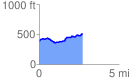
 2.749072 mi
 261.48 ft
 131.13 ft
 130.34 ft
 1.80 %
GPX Downloads: Track Route
![]()
|
| at: |
Sumter National Forest - Enoree District |
show on map
animate
2.749072 mi
261.48 ft
131.13 ft
130.34 ft
1.80 %