|
| at: |
Sumter National Forest - Enoree District |
Data from USFS GIS
 show on map
 animate
Trail users:


Elevation Profile
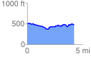
 4.296652 mi
 284.88 ft
 312.71 ft
 -27.83 ft
 1.38 %
GPX Downloads: Track Route
![]()
|
| at: |
Sumter National Forest - Enoree District |
show on map
animate
4.296652 mi
284.88 ft
312.71 ft
-27.83 ft
1.38 %