| at: |
Sumter National Forest - Enoree District |
Data from USFS GIS
 show on map
 animate
Trail users:


Elevation Profile
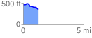
 1.242546 mi
 52.59 ft
 152.38 ft
 -99.79 ft
 2.32 %
GPX Downloads: Track Route
![]()
| at: |
Sumter National Forest - Enoree District |
show on map
animate
1.242546 mi
52.59 ft
152.38 ft
-99.79 ft
2.32 %