|
| at: |
Sumter National Forest - Enoree District |
Data from USFS GIS
 show on map
 animate
Trail users:


Elevation Profile
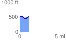
 1.109821 mi
 99.28 ft
 124.50 ft
 -25.22 ft
 2.12 %
GPX Downloads: Track Route
![]()
|
| at: |
Sumter National Forest - Enoree District |
show on map
animate
1.109821 mi
99.28 ft
124.50 ft
-25.22 ft
2.12 %