| at: |
Sumter National Forest - Enoree District |
Data from USFS GIS
 show on map
 animate
Trail users:


Elevation Profile
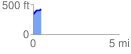
 0.450435 mi
 93.07 ft
 6.15 ft
 86.92 ft
 3.91 %
GPX Downloads: Track Route
![]()
| at: |
Sumter National Forest - Enoree District |
show on map
animate
0.450435 mi
93.07 ft
6.15 ft
86.92 ft
3.91 %