| at: |
Sumter National Forest - Enoree District |
Data from USFS GIS
 show on map
 animate
Trail users:


Elevation Profile
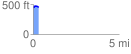
 0.321259 mi
 32.49 ft
 23.00 ft
 9.48 ft
 1.92 %
GPX Downloads: Track Route
![]()
| at: |
Sumter National Forest - Enoree District |
show on map
animate
0.321259 mi
32.49 ft
23.00 ft
9.48 ft
1.92 %