| at: |
Sumter National Forest - Enoree District |
Data from USFS GIS
 show on map
 animate
Trail users:


Elevation Profile
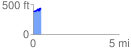
 0.461494 mi
 70.96 ft
 39.81 ft
 31.16 ft
 2.91 %
GPX Downloads: Track Route
![]()
| at: |
Sumter National Forest - Enoree District |
show on map
animate
0.461494 mi
70.96 ft
39.81 ft
31.16 ft
2.91 %