| at: |
Sumter National Forest - Enoree District |
Data from USFS GIS
 show on map
 animate
Trail users:


Elevation Profile
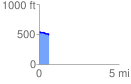
 0.624989 mi
 19.09 ft
 64.50 ft
 -45.41 ft
 1.95 %
GPX Downloads: Track Route
![]()
| at: |
Sumter National Forest - Enoree District |
show on map
animate
0.624989 mi
19.09 ft
64.50 ft
-45.41 ft
1.95 %