|
| at: |
Sumter National Forest - Enoree District |
Data from USFS GIS
 show on map
 animate
Trail users:


Elevation Profile
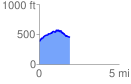
 1.953993 mi
 234.88 ft
 156.47 ft
 78.40 ft
 2.28 %
GPX Downloads: Track Route
![]()
|
| at: |
Sumter National Forest - Enoree District |
show on map
animate
1.953993 mi
234.88 ft
156.47 ft
78.40 ft
2.28 %