|
| at: |
Sumter National Forest - Enoree District |
Data from USFS GIS
 show on map
 animate
Trail users:


Elevation Profile
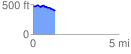
 1.287070 mi
 70.63 ft
 158.54 ft
 -87.91 ft
 2.33 %
GPX Downloads: Track Route
![]()
|
| at: |
Sumter National Forest - Enoree District |
show on map
animate
1.287070 mi
70.63 ft
158.54 ft
-87.91 ft
2.33 %