| at: |
Sumter National Forest - Enoree District |
Data from USFS GIS
 show on map
 animate
Trail users:


Elevation Profile
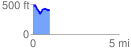
 0.994694 mi
 115.90 ft
 183.68 ft
 -67.78 ft
 3.50 %
GPX Downloads: Track Route
![]()
| at: |
Sumter National Forest - Enoree District |
show on map
animate
0.994694 mi
115.90 ft
183.68 ft
-67.78 ft
3.50 %