|
| at: |
Sumter National Forest - Enoree District |
Data from USFS GIS
 show on map
 animate
Trail users:


Elevation Profile
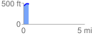
 0.418140 mi
 46.86 ft
 25.09 ft
 21.77 ft
 2.12 %
GPX Downloads: Track Route
![]()
|
| at: |
Sumter National Forest - Enoree District |
show on map
animate
0.418140 mi
46.86 ft
25.09 ft
21.77 ft
2.12 %