| at: |
Sumter National Forest - Enoree District |
Data from USFS GIS
 show on map
 animate
Trail users:


Elevation Profile
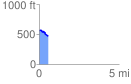
 0.578806 mi
 26.67 ft
 107.41 ft
 -80.75 ft
 3.51 %
GPX Downloads: Track Route
![]()
| at: |
Sumter National Forest - Enoree District |
show on map
animate
0.578806 mi
26.67 ft
107.41 ft
-80.75 ft
3.51 %