| at: |
Sumter National Forest - Enoree District |
Data from USFS GIS
 show on map
 animate
Trail users:


Elevation Profile
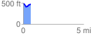
 0.625776 mi
 89.74 ft
 102.67 ft
 -12.93 ft
 3.11 %
GPX Downloads: Track Route
![]()
| at: |
Sumter National Forest - Enoree District |
show on map
animate
0.625776 mi
89.74 ft
102.67 ft
-12.93 ft
3.11 %