|
| at: |
Sumter National Forest - Enoree District |
Data from USFS GIS
 show on map
 animate
Trail users:


Elevation Profile
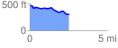
 2.551172 mi
 72.30 ft
 247.51 ft
 -175.21 ft
 1.84 %
GPX Downloads: Track Route
![]()
|
| at: |
Sumter National Forest - Enoree District |
show on map
animate
2.551172 mi
72.30 ft
247.51 ft
-175.21 ft
1.84 %