| at: |
Sumter National Forest - Enoree District |
Data from USFS GIS
 show on map
 animate
Trail users:


Elevation Profile
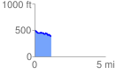
 1.183901 mi
 55.08 ft
 166.45 ft
 -111.36 ft
 2.66 %
GPX Downloads: Track Route
![]()
| at: |
Sumter National Forest - Enoree District |
show on map
animate
1.183901 mi
55.08 ft
166.45 ft
-111.36 ft
2.66 %