|
| at: |
Sumter National Forest - Enoree District |
Data from USFS GIS
 show on map
 animate
Trail users:


Elevation Profile
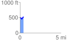
 0.436084 mi
 79.52 ft
 56.62 ft
 22.89 ft
 3.45 %
GPX Downloads: Track Route
![]()
|
| at: |
Sumter National Forest - Enoree District |
show on map
animate
0.436084 mi
79.52 ft
56.62 ft
22.89 ft
3.45 %