| at: |
Sumter National Forest - Enoree District |
Data from USFS GIS
 show on map
 animate
Trail users:


Elevation Profile
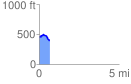
 0.686449 mi
 47.89 ft
 116.11 ft
 -68.22 ft
 3.20 %
GPX Downloads: Track Route
![]()
| at: |
Sumter National Forest - Enoree District |
show on map
animate
0.686449 mi
47.89 ft
116.11 ft
-68.22 ft
3.20 %