|
| at: |
Sumter National Forest - Enoree District |
Data from USFS GIS
 show on map
 animate
Trail users:


Elevation Profile
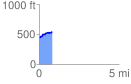
 0.800773 mi
 109.23 ft
 10.04 ft
 99.19 ft
 2.58 %
GPX Downloads: Track Route
![]()
|
| at: |
Sumter National Forest - Enoree District |
show on map
animate
0.800773 mi
109.23 ft
10.04 ft
99.19 ft
2.58 %