| at: |
Sumter National Forest - Enoree District |
Data from USFS GIS
 show on map
 animate
Trail users:


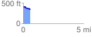
Elevation Profile
 0.575661 mi
 16.67 ft
 90.05 ft
 -73.38 ft
 2.96 %
GPX Downloads: Track Route
![]()
| at: |
Sumter National Forest - Enoree District |
show on map
animate
0.575661 mi
16.67 ft
90.05 ft
-73.38 ft
2.96 %