|
| at: |
Sumter National Forest - Enoree District |
Data from USFS GIS
 show on map
 animate
Trail users:


Elevation Profile
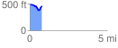
 0.797744 mi
 93.08 ft
 124.97 ft
 -31.89 ft
 2.97 %
GPX Downloads: Track Route
![]()
|
| at: |
Sumter National Forest - Enoree District |
show on map
animate
0.797744 mi
93.08 ft
124.97 ft
-31.89 ft
2.97 %