|
| at: |
Sumter National Forest - Enoree District |
Data from USFS GIS
 show on map
 animate
Trail users:


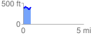
Elevation Profile
 0.642132 mi
 88.74 ft
 87.66 ft
 1.08 ft
 2.62 %
GPX Downloads: Track Route
![]()
|
| at: |
Sumter National Forest - Enoree District |
show on map
animate
0.642132 mi
88.74 ft
87.66 ft
1.08 ft
2.62 %