|
| at: |
Sumter National Forest - Enoree District |
Data from USFS GIS
 show on map
 animate
Trail users:


Elevation Profile
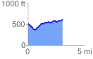
 3.101640 mi
 344.85 ft
 256.29 ft
 88.56 ft
 2.11 %
GPX Downloads: Track Route
![]()
|
| at: |
Sumter National Forest - Enoree District |
show on map
animate
3.101640 mi
344.85 ft
256.29 ft
88.56 ft
2.11 %