|
| at: |
Sumter National Forest - Enoree District |
Data from USFS GIS
 show on map
 animate
Trail users:


Elevation Profile
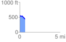
 0.670433 mi
 15.94 ft
 142.08 ft
 -126.14 ft
 4.01 %
GPX Downloads: Track Route
![]()
|
| at: |
Sumter National Forest - Enoree District |
show on map
animate
0.670433 mi
15.94 ft
142.08 ft
-126.14 ft
4.01 %