|
| at: |
Sumter National Forest - Enoree District |
Data from USFS GIS
 show on map
 animate
Trail users:


Elevation Profile
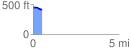
 0.547269 mi
 9.86 ft
 47.76 ft
 -37.90 ft
 1.65 %
GPX Downloads: Track Route
![]()
|
| at: |
Sumter National Forest - Enoree District |
show on map
animate
0.547269 mi
9.86 ft
47.76 ft
-37.90 ft
1.65 %