|
| at: |
Sumter National Forest - Enoree District |
Data from USFS GIS
 show on map
 animate
Trail users:


Elevation Profile
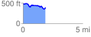
 1.913489 mi
 155.09 ft
 235.16 ft
 -80.07 ft
 2.33 %
GPX Downloads: Track Route
![]()
|
| at: |
Sumter National Forest - Enoree District |
show on map
animate
1.913489 mi
155.09 ft
235.16 ft
-80.07 ft
2.33 %