| at: |
Sumter National Forest - Enoree District |
Data from USFS GIS
 show on map
 animate
Trail users:


Elevation Profile
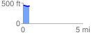
 0.548577 mi
 19.35 ft
 50.68 ft
 -31.33 ft
 1.75 %
GPX Downloads: Track Route
![]()
| at: |
Sumter National Forest - Enoree District |
show on map
animate
0.548577 mi
19.35 ft
50.68 ft
-31.33 ft
1.75 %