| at: |
Sumter National Forest - Enoree District |
Data from USFS GIS
 show on map
 animate
Trail users:


Elevation Profile
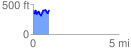
 0.940331 mi
 286.60 ft
 260.48 ft
 26.12 ft
 5.77 %
GPX Downloads: Track Route
![]()
| at: |
Sumter National Forest - Enoree District |
show on map
animate
0.940331 mi
286.60 ft
260.48 ft
26.12 ft
5.77 %