|
| at: |
Sumter National Forest - Enoree District |
Data from USFS GIS
 show on map
 animate
Trail users:


Elevation Profile
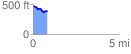
 0.816859 mi
 42.41 ft
 136.18 ft
 -93.77 ft
 3.16 %
GPX Downloads: Track Route
![]()
|
| at: |
Sumter National Forest - Enoree District |
show on map
animate
0.816859 mi
42.41 ft
136.18 ft
-93.77 ft
3.16 %