| at: |
Fort Mountain State Park Area |
Data from David Muse
 show on map
 animate
Trail users:

Elevation Profile
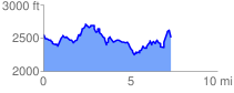
 7.408435 mi
 1633.66 ft
 1634.90 ft
 -1.24 ft
 4.18 %
GPX Downloads: Track Route
![]()
| at: |
Fort Mountain State Park Area |
show on map
animate
7.408435 mi
1633.66 ft
1634.90 ft
-1.24 ft
4.18 %