|
| at: |
Sumter National Forest - Enoree District |
Data from USFS GIS
 show on map
 animate
Trail users:


Elevation Profile
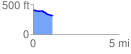
 1.134199 mi
 6.50 ft
 109.70 ft
 -103.20 ft
 1.83 %
GPX Downloads: Track Route
![]()
|
| at: |
Sumter National Forest - Enoree District |
show on map
animate
1.134199 mi
6.50 ft
109.70 ft
-103.20 ft
1.83 %